
Using the new GNSS base station
Description
 There is an ever increasing demand for increased spatial accuracy for field data collection and mapping. Given the steep terrain, northern latitude, and dense forest canopy conditions of Southeast Alaska, data collection with systems based solely on GPS has been difficult with mapping grade equipment, particularly when filtering for quality signals.
We now have additional Global Navigation Satellite Systems (GNSS) available for use, particularly the mature GLONASS constellation, that when paired with the United States’ GPS constellation tremendously increases productivity and accuracy of field data collection. GNSS rover receivers significantly increase productivity and accuracy for both public and private interests and extend academic and research opportunities. To realize the full benefit of GNSS receiver capability and maximize accuracy, the data collected with GNSS receivers must be corrected with GNSS reference data. While an extensive network of CORS and UNAVCO base references stations and even real-time WASS corrections are available for correcting only GPS data, southeast Alaska lacks a broader spectrum of GNSS correction capability. A GNSS reference base station will serve many interests and business areas.
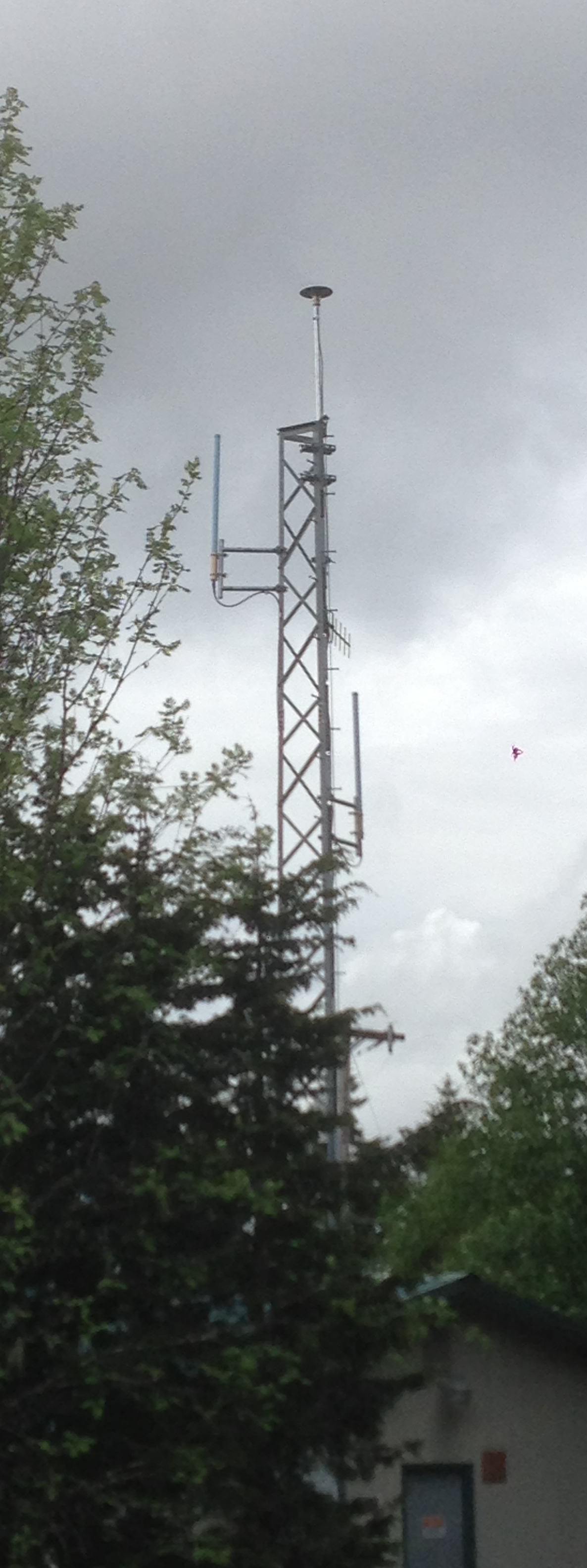
The Trimble NetR9 reference receiver supports a wide range of satellite signals; currently, the procured NetR9 platform is capable of tracking signals from GPS, GLONASS, Galileo, BeiDou and QZSS constellations. Additionally, real-time web broadcasted corrections are an option, but currently only GPS and GLONASS signals are being tracked.
How To
A new USFS sponsored GNSS base station has been activated in Juneau. The guide will assist you in setting up that station as a user defined station in your GNSS post processing software.
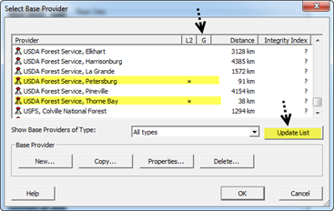
There are currently 3 Alaska Region USFS sponsored GNSS base stations. The first two (Thorne Bay and Petersburg) have been in place for a while but, NOW they will automatically show up as a base provider in your GNSS software, such as Trimble Pathfinder Office or Trimble Positons, that utilize the Global Reference Station List. You'll likely have to update your provider list for them to appear. Currently, they don't show as if they are GLONASS capable (with an * under the G), BUT they are. A ticket has been placed with Trimble to fix this error in the listing and hopefully will be corrected soon. But rest assured, you can post process your GLONASS data (and GPS) with those stations.
The new Juneau station is being registered now and will also soon appear with the other listings, negating the need to set it up a user defined station.
This is a screen shot from PFO illustrating the update list button and the two USFS GNSS base stations. Again, they are GLONASS capable even though the listing doesn't indicate that fact.
Locations
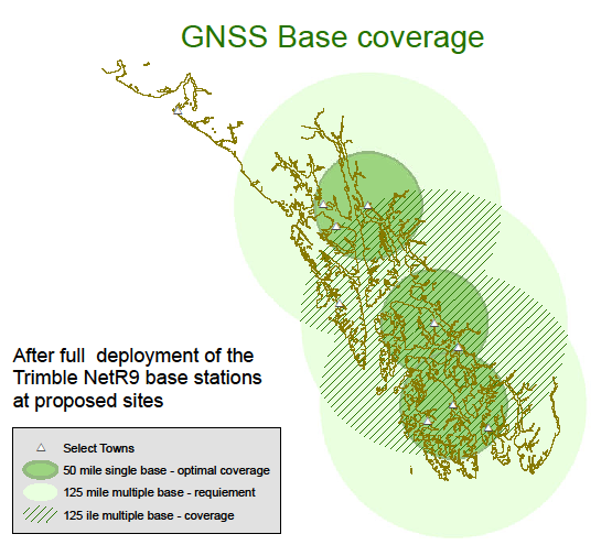
Targeted spatial distribution optimizes coverage for areas of active management where precision data collection is of high priority. To meet H-Star / duel frequency post processing base line requirements, it is recommended that post processing with a single base provider be within 50 miles (80 km) or 125 miles (200 km) with multiple base provides.
The following three sites were chosen as preferred alternatives. Thorne Bay, Petersburg, Juneau
Postion Solutions
These are the solutions used to calculate the ITRF00 Ep. 1997.0 positions. These solutions are in reference to one 24hour static collection but that collection was chosen from among several collected where the it was closest to the average of all collections and in consideration of the RMS values.
REF FRAME: NAD_83(2011)(EPOCH:2010.0000)
| GNSS Station | |||
|---|---|---|---|
| Parameter | Juneau - NSRL | Petersburg - PRD | Thorne Bay - TBRD |
| X | -2354750.746 | -2384561.156 | -2435945.003 |
| Y | -2387014.702 | -2561428.245 | -2655633.151 |
| Z | 5407513.254 | 5314474.801 | 5244948.720 |
| LAT | 58 22 13.73413 | 56 48 41.96926 | 55 41 15.62279 |
| E LON | 225 23 23.44688 | 227 2 52.82564 | 227 28 14.26481 |
| W LON | 134 36 36.55312 | 132 57 7.17436 | 132 31 45.73519 |
| EL HGT(m) | 25.747 | 31.699 | 36.844 |
| ORTHO HGT(m) [NAVD88 (Computed using GEOID12A)] | 23.6220.100 | 33.237 | 40.803 |
REF FRAME: IGS08
| GNSS Station | |||
|---|---|---|---|
| Parameter | Juneau - NSRL | Petersburg - PRD | Thorne Bay - TBRD |
| EPOCH | 2014.7109 | 2013.4343 | 2013.2918 |
| X | -2354751.714 | -2384562.097 | -2435945.935 |
| Y | -2387013.616 | -2561427.141 | -2655632.037 |
| Z | 5407513.447 | 5314474.982 | 5244948.891 |
| LAT | 58 22 13.73997 | 56 48 41.97698 | 55 41 15.63100 |
| E LON | 225 23 23.35757 | 227 2 52.74071 | 227 28 14.18240 |
| W LON | 134 36 36.64243 | 132 57 7.25929 | 132 31 45.81760 |
| EL HGT(m) | 25.862 | 31.759 | 36.878 |
| ORTHO HGT(m) [NAVD88 (Computed using GEOID12A)] | 23.6220.100 | 33.237 | 40.803 |